Here are some memories from our trip July 2012 to North Uist. Sorry about the quality but if you keep the window small its not too bad. Hope you enjoy.
Big Wave.
David A.
 |
|
Landing at Belnahua. South,
numerous Islands add to the beauty of this area. In the background the Island of Scarba
dominates the skyline with the Paps of Jura in the distance.
|
 |
|
The campsite with a 5***** view. I suppose it will do!!!
.JPG) |
 |
|
Now derelict, the houses of the
slate workers and their families have been uninhabited for nearly a century. This small island once supported
150 people at the height of its industrial prosperity during the great days of
the slate boom. Quarrying was shut down at the beginning of World War 1 as the
entire male population enlisted in the armed forces or went to work in the
Clyde shipyards. The womenfolk were unable to keep the quarries from flooding
and eventually moved to nearby islands or joined their men folk in Glasgow.
|
 |
|
The Island has many derelict
buildings on it: two rows of workers house and out buildings; a school house,
manager house and slate quarry work buildings. In the sound lies Fladda Island
with its lighthouse, Luing Island and in the distance the mainland of Scotland.
|
 |
|
A relic from the past: old, worn
and past its best, and in the foreground rusting machinery.
|
 |
|
No matter which way you look the
views are magnificent.
|
 |
|
Geylag Geese are resident on
the Island. |
 |
| Jim surveys the surroundings. |
 |
| North in the distance lies Easdale. |
 |
|
Myself with Fladda Island in the Sound of
Luing. The name Fladda originates from the old Norse
for 'flat island'. Fladda has a lighthouse and lighthouse keepers' cottages
built in 1860 by brothers David and Thomas Stevenson. |
 |
|
Heavy rain over the Island of Mull. |
.JPG)
 Looking back, the Island of Eigg and Rhum, shimmered in the morning heat.
 Passing Eilean a' Ghaill, and in the distance Ardnish, and the Moidart Mountains. Just wonderful.
 Eilean a’ Ghaill (Stranger's Isle),which has the remain of an ancient fort on it.
 Ardnish and the Mountains of Moidart, shrouded by morning the cloud. All around, my world was awash in a serenity of blue hue. Sometimes, I find it impossible to convey through words the emotions that are awakened by the riches that are experienced in the natural environment, and this time is one of them.
 Ardnish and the Mountains of Moidart seemed to beckon me, and soon I had reached Ardnish, gliding between Rubha Chaolais and Eilean a' Chaolais. I had been on the water for about two hours and had experienced some of the most inspiring and leisurely paddling ever. As ever I was welcomed and escorted by some seals as I headed to find a place to camp. I had wanted to explore the ruined crofts and fish the hill lochs in this area. As it turned out, the area of Ardnish, has its own very special atmosphere. Yet again, another wonderful area,a magical place, where the past lingers and can be felt .
 Large numbers of swallows skimmed above the lush meadow in front of the ruins feeding and chattering in the warn morning sun along with numerous butterflies. I lay on my sleeping bag for a moment and closed my eyes, you could feel the peace and tranquillity of the area: bees and insects buzzed as they fed on the machair flowers, terns and swallows chattered and the waves gently lapped the sea shore. I felt I was home.
 The bothy . All bothies have their own character.


 The shellfish life on this part of the coast is prolific. A nearby bay contained a few pockets of wild oysters. When the tide is out there is a sandy bottom exposed. The shallows are alive with sand eels, small shoals of fish, crabs and many juvenile flatfish. I even saw some bigger flatfish (pan size) flap of into deeper water, leaving a trail of sand in their wake.
 Peanmeanach is an abandoned settlement on the Ardnish peninsula. A sad lonely row of roofless 'black-houses' stand on a raised beach. The name Peanmeanach originates from the Norse system of land division. An ounceland was a large area of land thought capable of producing enough for an ounce of silver in rent. Each ounceland was divided into twenty pennylands, or farms. The other part of the name, 'meanach', is Gaelic for 'middle'.
 After a few cups of tea I headed into the hills to fish a few of the hill lochs that hopefully contained trout in their peaty waters. The walk from my camp at the shore to the hill lochs was beautiful; the small strip of machair, then the meadow, the wet meadow at the rear of the ruins was alive with different types of dragon and damsel flies, and butterflies. You then enter a small birch and oak wood which was dappled with sunbeams shinning through the leaves, ferns and mosses adorn the banks of the woodland, and the air was filled with bird song.
 The wild brown trout were not big, but they fought well and had beautiful markings.
 Later back at camp I tried to read my book that evening in the tent: Neil Gunn’s, Silver Darlings, but again fell asleep before ending the paragraph. The early rise and walk in the hills had taken it out of me-zzzzzzz.
 Scotland’s national symbol.
 The legend of the thistle: relates how a sleeping party of Scots warriors during the rein of the Scottish King Alexander 111 (1249-1286), were almost set upon by invading Vikings and were only saved when one of the attackers trod on a wild thistle with his bare feet. His cries raised the alarm and the roused Scots duly defeated the Norsemen. In gratitude, the plant became known as the Guardian Thistle and was adopted as the symbol of Scotland.
 I paddled on to explore An Glas-eilean and other islands and skerries that lie at the mouth of Loch Nan Uamh. Flightless black back gull chicks strutted about the skerries as the adults sinisterly patrolled the skies overhead. Shags dived from the rocks into the pristine waters of the Sound and the shinny heads of inquisitive seals bobbed around the kayak giving the occasional snort.
I beached the kayak at a near by bay next to another two kayaks to view a bothy that sits high on a cragg. Inside the bothy were Andy, and Perry, kayakers from Sheffield who had set up home for the night. They were kind enough to invite me to stay for the night but I wanted to push further along the coast. I hope you managed to see the otters.
I was soon paddling along the southern coast of the Arisaig Peninsular. My companions were the delicate and streamlined terns as they dived for eels in the turquoise waters near the shore and the occasional red deer as they grazed on the succulent summer grass on the small hill tops that run up from the sea.
There are many places to camp along this area, but I found this little bit of paradise to set up camp.  The view from a hill top of the campsite.
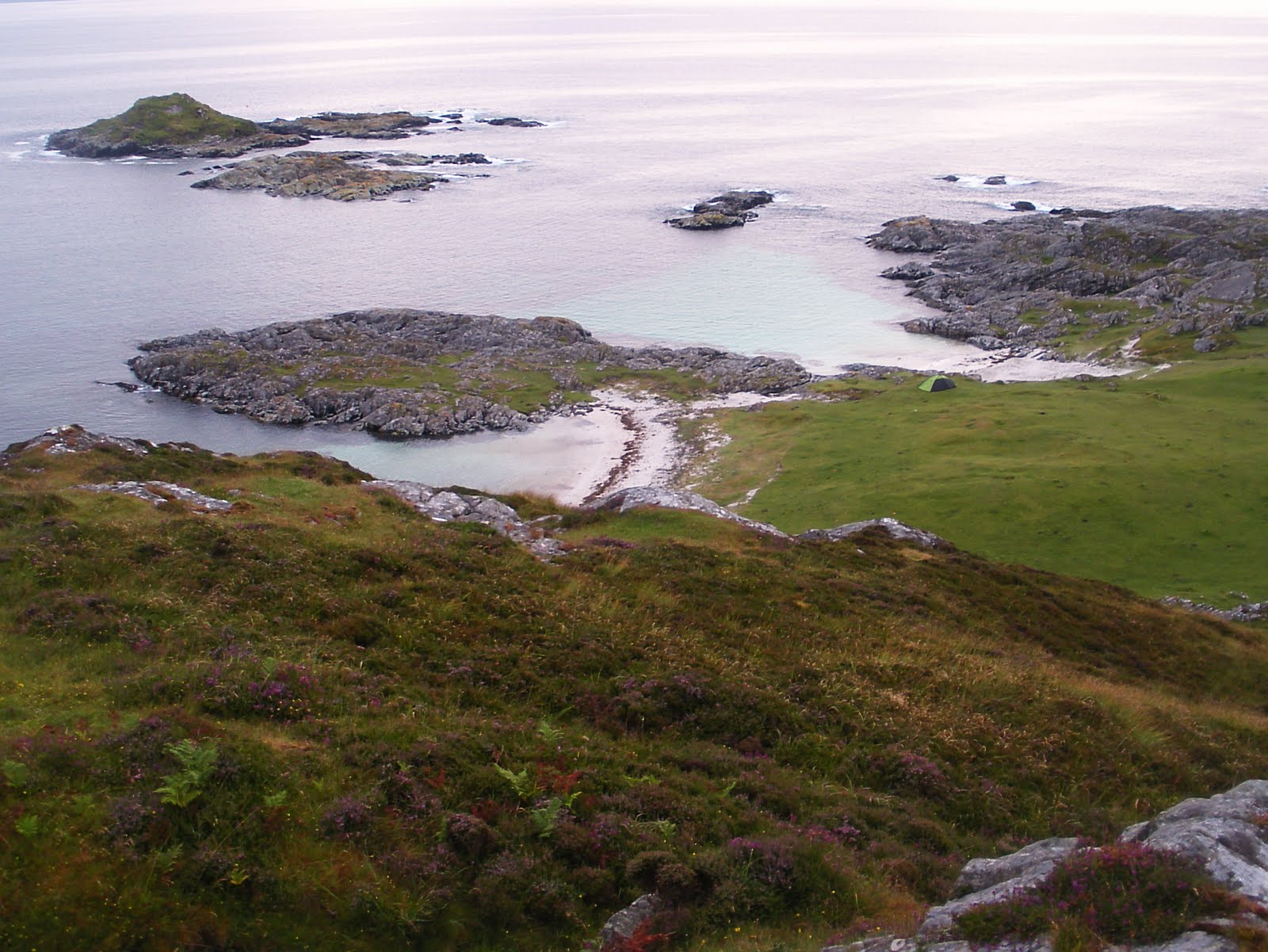 What a view from the tent door.
 A wonderful end to a perfect day, the Island of Eigg shrouded in cloud. Stunning, just stunning.
 The skies were mostly blue and the sea was calm as I paddled to explore the numerous islands and skerries that lie at the mouth of Loch nan Ceall, west of Arisaig village.
  The Island of Eigg and Rhum in the distance. These skerries and islands were a haven for seals and other wildlife.
 A convenient sign post for sea kayakers looking for the village of Arisaig.
  Back at camp and after a well deserved meal I was of fishing from the shore around the bay, with some success.
A Coalfish.
 A Pollock.
 The end of another memorable day, and another fantastic sunset.
 Day 3
Day 3
Today I would break camp and head back east along the coast towards the Ardnish area. It was hard to leave this wonderful campsite and the wildlife that I had shared it with: otters, seals, ravens, herons, terns diving for eels and gannets further out. The list could go on and on.
Cliodhna packed and ready to go.  The journey will continue in the posting: Arisaig to Ardnish.
David A.

 That evening I fished from the rocks and caught several Pollack.

 We also had the privilege of seeing two Sea Eagles as we neared the mouth of the entrance that takes you into Portree Bay. This would be our last night on Skye and we wanted to be somewhere, near our exit point, to come of the water the next day. There is a good camping area at Camas Ban (OS, 491 424), it has a beautiful sandy beach and has some well drained short grass. We paddled into Portree to get something to eat, before heading back out to Camas Ban to set up camp. After breaking camp the next morning we slowly paddled to the shore of Portree, and the adventure was sadly over.
 The End.